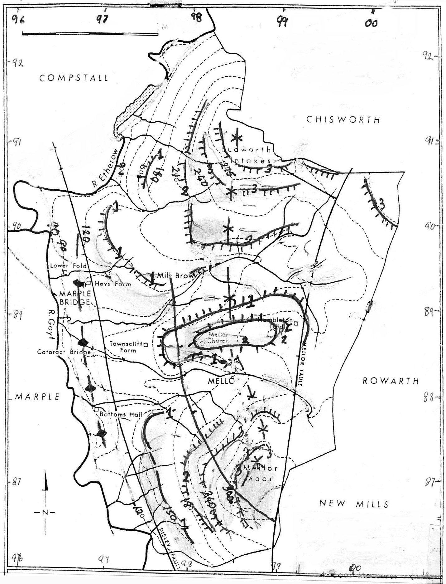
Figure 1 - A Sketch Map of the Relief and Geology in Mellor
|
R. H. Johnson.
NOTE:
This article has been written as a contribution to the 2008 Mellor History Project which is sponsored by the Mellor Archaeological Trust.
This paper describes how the landscape has evolved before people settled in the area and how the geological history has influenced past historical events in Mellor.
In preparing the illustrations the author has made use of Google Earth, which he is pleased to acknowledge. Readers should be aware however, that copyright of the images remains with Google Earth and the illustrations may be copied only for private use.
The Parish of Mellor is located on the east side of the Goyt and Etherow valleys immediately upstream of the river confluence at 89 metres above sea level (asl). The Parish has a topography of low hills and small valleys with the highest land on Mellor Moor (327m asl) and Brown Low (292m asl). Two relatively minor streams, the Mill (Brow) Brook and the Mellor Brook, have eroded the main valleys in the parish but there are also several deep gully features etched into the lower slopes of the Goyt and Etherow valleys. In this study the landforms which constitute the Mellor Landscape will be examined and explanations to past geological and glacial history given.
Figure 1 - A Sketch Map of the Relief and Geology in Mellor
|
The geological imprint on the Mellor landscape is very strong. A succession of Carboniferous strata 354 to 290 million years old (354-290 M a) provides the basic elements of the relief, but is overlain in many areas by a veneer of Pleistocene glacial sediments which thicken when traced down slope and are many metres thick in the Etherow and Goyt valleys. The Carboniferous rocks consist of sandstones and clayrocks that are of Namurian (Millstone Grit Series) age. Others valleys are of Westphalian (Coal Measures) age. The sandstones are the more resistant rocks and provide a bold topography of steep scarps wherever they crop out (Figure 1).
They form a capping to the highest hills in Mellor and give a 'step like' appearance to the slopes to the west of Mellor Moor and in the Mill Brook valley (Plate 1). Three particular sandstones (a massive sandstone in the Rough Rock Group which can be over 25 metres thick in Mellor (Stevenson et al 1971); the Woodhead Hill Rock; an unnamed sandstone within the Coal Measures) form strong escarpments that overlook the more gentle slopes that have developed on the less resistant rocks (Figure 1). The sandstones provide better-drained soils than the shale or mudstone clayrocks or the glacial clays and are areas of water storage (aquifers), because their jointing and bedding allow the retention of ground waters. Traced laterally, the resistant sandstone scarps decrease in height as their joint frequency, rock thickness and angle of dip change. In some places the strata have been affected by faults, which cause the displacement of the escarpments or benches and their abrupt termination at the fault lines. Since fault fractures are lines of weakness, they are often marked by stream gullies.
At the base of the sandstones where they overlie impermeable mudstones and shales, the ground waters from these aquifer sources supply numerous springs and a constant runoff to the local streams. Where they crop out in Mellor, the mudrocks, coals and clays are more easily weathered and have a low permeability. They tend to produce more gentle and long slopes that are concave in profile and extend down slope from the steeper sandstone scarps. Because they are often overlain by hill wash the slopes have only moderate to poor drainage and are susceptible to mass movement including land sliding and soil flow.
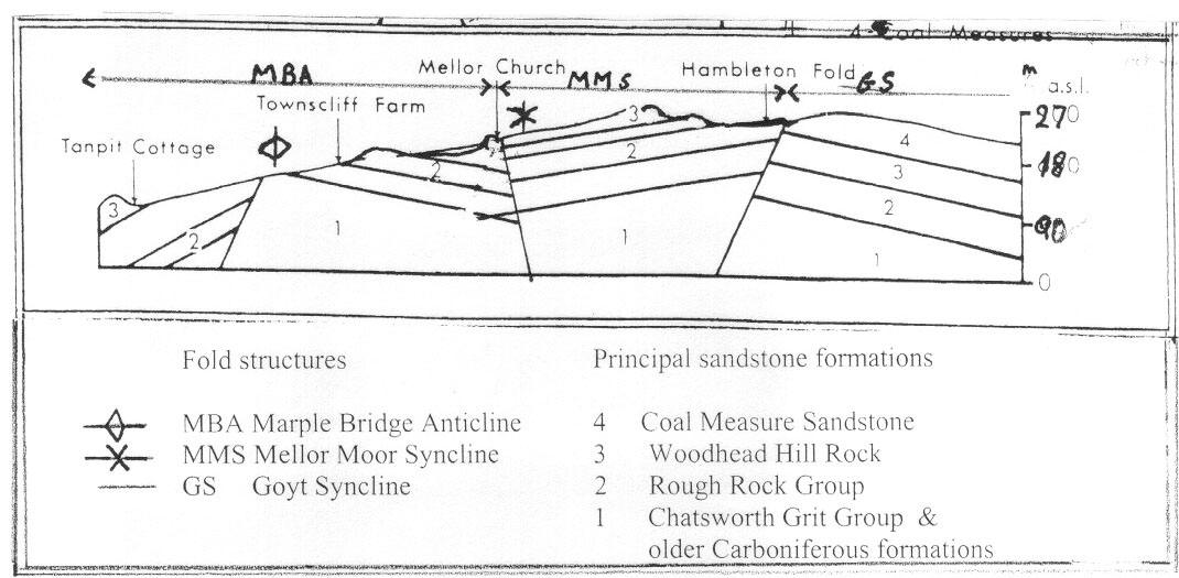
Figure 2 - A Schematic Geological Section from Marple Bridge to Cheetham Hill showing the distribution of Fold and Fault structures
The occurrence and distribution of rock outcrops in Mellor is not a random pattern being controlled by past tectonic conditions which occurred when Variscan earth movements affected the area some 290 M a. (million years) ago. The main elements of the topography are strongly influenced by these movements which controlled the pattern of the Carboniferous outcrops in Mellor. During the Variscan Orogeny, (a period of mountain building circa. 390-310 M a), a number of fold structures were formed along the western flank of the South Pennines whose axes are aligned north-south. North of Mellor, the Mossley Anticline is the major fold structure, an asymmetrical fold with a steep western limb (Chadwick, 2002). When traced southwards it branches into a series of en-echelon north-south trending folds that include the Goyt Syncline, which extends from Lantern Pike near Rowarth (Plates 2 and 3.) to the Roaches near Leek. This is the dominant structure of the area between Mellor and Hayfield and its erosion into a series of scarps and vales is readily viewed from the ridge at Shiloh.
To the west of Mellor is an up-fold or anticline identified by the British Geological Survey as the 'Marple Bridge anticline' (Figure 1). This is a much smaller fold whose limbs dip steeply and has been strongly deformed by faults, one of which coincides with the axis of the fold (Stevenson et al 1971a). This fault can be traced along the floor of the Goyt Valley from Disley via Hague Bar into the areas immediately to the east of Strawberry Hill and Cataract Bridge and from there to Compstall (Figure 1). This particular line of weakness largely controls the alignment of the Goyt Valley from Hague Bar northwards to Marple Bridge. Between the Goyt Syncline at Rowarth and the Marple Bridge anticline there is a minor synclinal fold whose axis parallels the other folds and can be traced from Mellor Moor northwards via the Woodhead Hill Rock scarps to the east of Mellor Church (Figure 2), and then north to Brown Low and Ludworth Moor (Figure 1). East of this syncline is the Mellor Fault (Figure 1) whose throw to the west has displaced strata including Lower Coal Measures rocks some 150 metres downwards. These rocks now form the highest relief of the Mellor area and contain several coal seams including the Six Inch and Yard seams that were mined in times past.
Carboniferous strata were buried by great thicknesses of sedimentary rocks. At the close of the Mesozoic the opening of the North Atlantic Ocean led to tectonic changes in British Isles with several areas, including the South Pennines, becoming areas of higher relief (Holdsworth et al 2002). This uplift is still in progress but was especially active during the Palaeocene (circa 55 M a), and the Oligocene (circa 30 M a) Periods. Throughout these latter periods erosion has taken place and it has been estimated that during the 25 million years of denudation since the Oligocene, some 1,000 to 2,500 metres of post-Carboniferous strata were removed (Chadwick, 2002). Given these denudation rates of between 0.04 and 0.10 mm/yr it is probable that the Carboniferous strata visible in Mellor today were only exhumed in the last 5 M a. and, in this very limited span of geological time, they have been eroded into their present form and a modern drainage system evolved. This time span includes the Pleistocene Epoch, when for 2.5 M a. climatic changes took place in which erosion rates, although varying, were generally greater than in other Cenozoic periods.
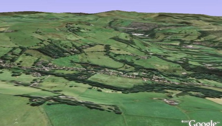
Plate 1
|
A Google Earth Image looking southwards and showing the Mellor Brook valley in the centre with the Goyt valley aligned north-west to south-east and in the image diagonally from top centre to the middle of the right margin. The image shows how the sandstone outcrops influence the relief giving a stepped appearance to the landscape (see text). The small meltwater channel located between Knowle Farm and Slack Wood is visible in bottom right part of the image. |
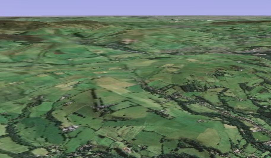
Plate 2
|
Viewed from the north, a Google Earth view of the Mill Brow and Mellor Brook valleys in the foreground and Rowarth Valley, Hayfield and Kinder Scout at the top of the image. The Goyt valley south of New Mills is shown in the top left of the plate. The north-south axis of the Mellor Moor syncline is located on the high-relief area in the middle of the picture. |
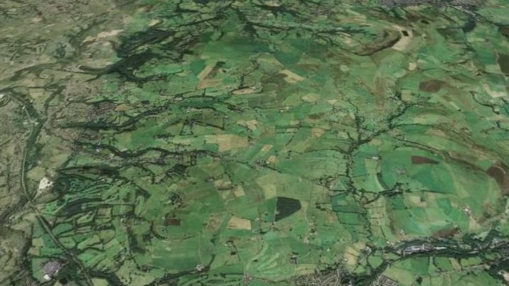
Plate 3
|
Looking northwards from above
New Mills this Google-Earth image shows the varied relief of the Mellor Parish. To the east, is the Rowarth valley where the northern end of the Goyt Syncline forms the high relief of Lantern Pike. To the west is the Goyt valley whose lower eastern slopes are overlain by thick glacial deposits. On the valley sides of the tributary streams, they are covered by woodland. In the centre of the image the high relief between Cobden Edge in the south and Brownlow Hiill in the north is influenced by the presence of the minor Mellor Moor syncline which controls the pattern of the Carboniferous rocks outcrops in this area. |
The record of events of the Early and Middle Pleistocene Period are to be found only in East Anglia, the Thames and Severn valleys and the English Midlands as successive glacial incursions in Northern England have destroyed the landforms and sedimentary record of earlier glacial events. In Mellor the glacial landforms and sediments date from the end of the Late Devensian cold stage, now renamed the Last Glacial Maximum Stadial. The maximum extent of this ice sheet occurred some 23-20 thousand years ago (23 - 20 k a), but by 16.5 k a. the ice had melted and ice sheets were no longer present in any part of Southern Britain (Burroughs 2005).
Erratic boulders and rocks transported by this ice sheet indicate that the glacier sources were in the western Scottish Highlands, Islands and Southern Uplands, the Lake District and possibly the northern approaches to the Irish Sea Basin. Ice streams flowed southwards from these sources and while most of the ice moved into the southern Irish Sea region, a substantial part of the ice sheet was deflected east towards the Lancashire and Cheshire lowlands. This ice lobe extended south as far as Worcester and to the area west of Birmingham (Worsley, 2005). The ice sheet would have been highly mobile and unstable, being some distance from the main ice accumulation areas, but at the time of the maximum ice sheet transgression the area around Manchester was buried under ice 300 - 500 meters thick. Towards its margins the ice sheet would thin rapidly, but in the Mellor area ice covered the low hills and extended eastwards to Hayfield and Chapel-en-le-Frith (Stevenson et al 1971b), where the ice margin was at least 380 - 360 metres asl, (above sea level). It is important to note that there was no ice sheet or ice cap developed within the Southern Pennines and any ice reaching the west Pennine hill margin came from the northern sources already mentioned. Some very small glaciers were possibly formed at Seal Edge, on the east flank of Kinder Scout (Johnson 1987, Johnson et al 1990), but most of the central parts of north Derbyshire, although snow covered, remained ice-free at this time. Because of these special conditions at the west Pennine hill margin there was little actual erosion by ice; its former presence is marked by the legacy of glacial deposits together with a number of significant changes caused by meltstream erosion and deposition.
When reconstructing the glacial history of Mellor and its surrounding area there are two factors of major importance that must be considered. The first is that Mellor was part of a marginal zone of an extensive and thick ice sheet that covered all the area between the South Pennines and North Wales. At the margins and within the hilly uplands, the greatest thickness of ice was in the valleys and not on the higher hill slopes which - when the ice first began to melt - were exposed, with parts of the ice sheet still covering the lower slopes. The second factor relates to the meltwaters released as the ice sheet disintegrated. These streams (and others supplied from the snow fields formed on the higher hills of the Goyt and Etherow catchments) would be impeded by, and frozen into, the ice covering the lower slopes of the valleys. For a time some of these meltwaters used the meltwater channel at Disley (Figure 5) to leave the Pennine area and pass into the ice sheet still present over the Cheshire Plain. However once this channel was abandoned, the melt streams were impeded by the ice barrier still present in the Goyt valley to the north of New Mills and could not escape from the uplands until this particular part of the ice sheet had melted. These two factors were of major importance when considering how the landscape evolved and the legacy of the Pleistocene Epoch in the Mellor area.
Some 130 - 140 years ago, E. Hull and his colleagues in the British Geological Survey (1864) identified a series of glacial and fluvial sand strata separating layers of glacial 'clay with boulders' (namely the Upper and Lower Boulder Clays) in the Pennine valleys draining towards Manchester and also over extensive areas of lowland Lancashire and Cheshire. They believed that this tripartite succession of Upper and Lower Boulder-clays separated by a 'Middle' sand and gravel member, characterised a pattern of glacial deposition which was widespread throughout northern England. Such a pattern was interpreted as evidence for two major glacial ice sheet advances separated by a series of outwash sand and gravels (Middle Sands) formed during a retreat stage during the Late Pleistocene Epoch. This tripartite division of the stratigraphy was accepted in the Manchester area for well over a hundred years and detailed mapping of the exposures of the glacial sediments found on the lower slopes of the Goyt and its tributary valleys (Rice 1957, Simpson 1959) appeared to confirm this sedimentary sequence upstream from Stockport to areas south of Whaley Bridge. Similar deposits in the same stratigraphical succession also occur in the Etherow valley upstream of Compstall (Stevenson et al 1971b).
However, recent studies in modern glacier environments have shown that this tripartite division is an over-simplification. The Middle Sands is a complex series of deposits which were formed in environments that varied from place to place and from time to time. This has meant that the present day topography of glacial landforms and deposits cannot be explained by such an interpretation. It is now generally accepted that rather than the slow advance, retreat and subsequent re-advance of the ice during the Last Glacial Maximum there was one period of rapid expansion from the source areas resulting in an unstable ice sheet at the time of the Maximum advance (Bennett and Glasser 1999). This ice sheet subsequently melted very rapidly and the Lower Boulder Clay is now regarded as a lodgement till deposited at the base of still-active mobile ice and consisting of a heterogeneous assortment of particles ranging form boulders or erratics (some of which had come from the Lake District and Scotland) to clays derived for the most part from Carboniferous, Permian or Triassic rocks over which the ice had passed. Often in such a till the stones which had been transported at the base or within the ice mass, are orientated in the direction of ice movement. When freshly deposited the till is grey-blue in colour, but after weathering it becomes a yellow-brown stony clay that forms the subsoil on most Mellor slopes.
Other tills, which include the Upper Boulder-Clays, were derived from supra-glacial and en-glacial debris which, having travelled within the ice mass, had melted out from the ice upper surface or edges. These were then further disturbed by slumping or other mass movements and are now recognised as flow tills. Such deposits were formed at the end stage of the Glacial Stadial which was characterised by a rapid disintegration with some parts of the ice sheet decaying in situ. Less compact than the lodgement tills and having no marked stone orientation, these flow tills are only recognisable when exposed as a thin layer overlying fluvio-glacial sand and gravels.
The 'Middle Sands' consist of well-sorted sands which vary from 1 to 5 metres in thickness and are sometimes intercalated with thin silt seams and lenticular gravel beds. These sediments (exposed mostly on the lower slopes overlooking the Goyt valley) are a product of meltstream activity taking place within, or at the front or margins of, the decaying and largely immobile ice body. In such environments, well-stratified sand and gravels could have been deposited as melt stream channel deposits which vary in composition from time to time and place to place. In some sites the sands and gravels were deposited as part of a valley sandur (Crofts 2005) i.e. a gravel plain constructed from glacial outwash by meltstreams flowing into pro-glacial areas. Such a sandur would extend in length as the ice down-wasted and the ice sheet retreated from the Pennine valleys. Alternatively, these beds may have been deposited where a delta was formed in an ephemeral lake, again at the ice margin.
A third possibility is that the sands and gravels were deposited at a very late stage in the ice sheet history when ice in the valleys had down wasted to such an extent that it became heavily crevassed and porous, thus enabling meltwaters flowing towards the ice sheet front to penetrate into the ice and erode channels beneath it (Glasser and Smith 1999). The streams in these 'canal' or 'tunnel' channels would often flow under hydrostatic pressure and would be maintained by very high water discharge conditions at the time of summer melting. During winter the volume of meltwater would be substantially reduced and some of the subglacial tunnels would close or become choked with glacio-fluvial sediment. The next melt season would see new tunnels eroded or the streams diverted to the outer edges of the ice still remaining in the valley. With the final melting of the ice, flow till sediments would be deposited forming a layer within or on top of the stratified sediments.
It should be noted that these three hypotheses used to explain the occurrence of the well-stratified glacio-fluvial sands and gravels are not mutually exclusive. The meltwater streams could have been aggrading the valley floor with sandur deposits, building deltas or flowing in tunnels concurrently at several locations or have operated in these ways in the same location but at different times during the down-wasting of the ice. The paucity of good exposures of the sand and gravel beds makes it impossible to verify the origin of the 'Middle Sands' at any particular location.
Figure 3 - Present day Distribution of Glacial deposits and erosional features in Mellor (based on 1965 Geological Survey 1:10560 Maps, SJ 98 NE & SJ 99 SE also SK 08 NW and field data).
|
These glacial depositional models provide the basis for a fresh interpretation of the local landscape and how it was affected by the cold climate conditions of the Last Glacial Maximum Stadial. In Mellor the local relief of the Pennine hills strongly influenced the depositional conditions at the ice sheet margin. The deposition of the lodgement tills was extensive and covered nearly all the slopes (Figure 3). With the later melting and down wastage of the ice these basal deposits were exposed in the tributary valleys although frequently overlain by fluvio-glacial and lacustrine sediments transported by meltwaters with a veneer of flow till sediments covering the meltwater deposits.
The British Geological Survey Maps record isolated mounds of sand and gravel, sometimes capped with till, which occur in Mellor on the upper slopes at Lane Ends (SJ975 902, SJ978 002) Lower Bradshaw (SJ 995 895) and near the Moorfield Arms (SK 002 894, SK 003 896). Although the origins of these depositional features are obscure, they were probably formed during at an early stage of the ice sheet decay when the hills began to emerge from beneath the ice cover and meltwaters began to redistribute the glacial debris derived from the surface of the ice sheet. Typical landforms found in such environments include
a) Kames where meltwaters had formed deltas in small
ponds on the ice sheet surface: when the ice melted these sediments were lowered
onto the ground surface;
b) Eskers created in tunnels located beneath the thinning ice edge; and
c) Kame terraces where the fluvio-glacial sediments were deposited in channels
eroded by streams flowing between the decaying ice margin and the newly exposed
upland slopes.
In Mellor there are also some meltwater erosional landforms formed when the ice began to melt and expose the upland slopes. Meltwater from ice in the Mill Brook valley flowed across the divide at Shiloh eroding a 'col' channel leading into the Rowarth valley (Figure 3. Map reference SJ 998 893). Such meltwater channels have no valley head, are steep sided and often sinuous, and have no downstream continuation beyond their outlet. A much bigger col channel occurs at Ludworth Intakes providing one of the best examples of this type of meltwater channel to be found anywhere in England. It cuts across a minor divide at its lowest point and is a steep-sided valley sinuous in form and 8 - 9 meters deep (Figure 3 and Plate 4). The channel floor at its southern end has been in-filled with two metres of peat and the walls of the channels are less steep today than when they were first formed. Like a railway cutting in appearance, the channel was eroded when the ice sheet lingered in the valleys and the higher relief was beginning to emerge from beneath the thinning ice cover. At this time meltwater, flowing under hydrostatic pressure beneath the ice, would begin to erode on the lee side of the col and by headward back-cutting erode a channel (Benn & Evans 1998). Meltwaters would use this channel until the local ice surfaces melted down to levels below that at which it could function. The very high discharge required to erode such channels probably came from surges of meltwater released from the ice during each seasonal ice melt. A third meltwater channel was eroded at a much lower level on the valley slope immediately to the east of Slack Wood and west of Knowle Farm (SJ 979 888 and Plate 1). Like the Ludworth channel, it is sinuous in form with steep sides but it is no longer used by a stream .It was eroded by meltwaters at the edge of an ice lobe that still covered the lower slopes of the Mellor Brook valley.
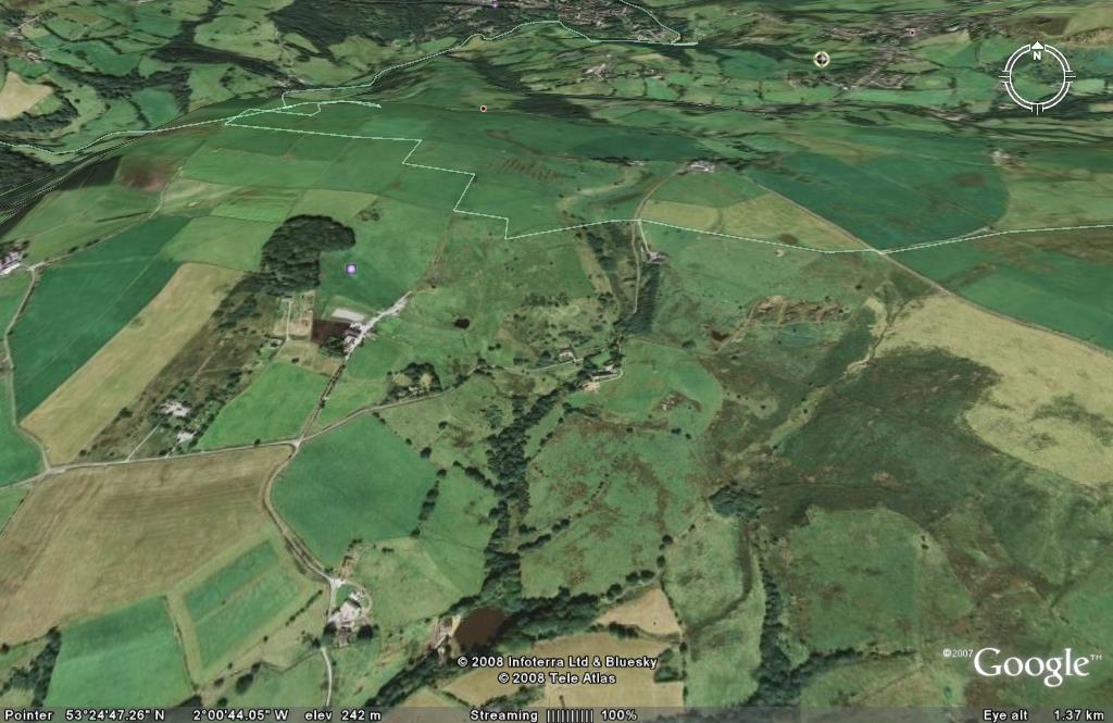
Plate 4
|
This image shows the northern boundary of the Mellor Parish in the Ludworth Intakes area to the north of Mill Brow. The large meltwater channel located here and described in the text is clearly visible in the top centre part of the image. |
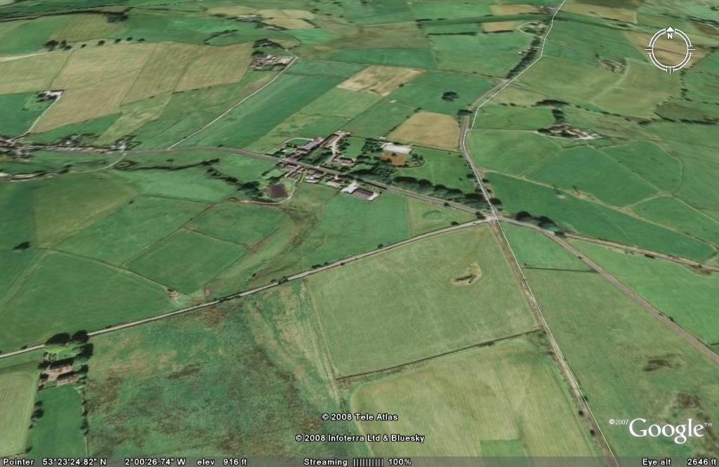
Plate 5
|
This image shows the area to the south of the cross roads at Cheetham Hill and shows the location of the glacial chute feature described in the text. Bogguard Road trends diagonally across the view from north-east to south-west. To the south and east of this road there is only a small catchment area but meltwaters in the past have eroded a deep sinuous channel which is visible to the south of the road junction at Cheetham Hill. |
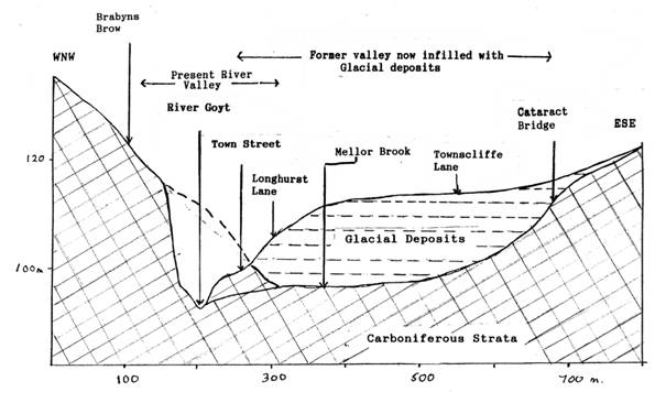
Figure 4.
|
In the centre of Marple Bridge the River Goyt is confined within a gorge, 900 metres in length and 25 - 30 metres deep, incised into Carboniferous rocks. On the western bank in Marple, Carboniferous (Westphalian) sandstones and shales are exposed, but on the eastern side of the river, the gorge is not so easily recognised except where some sandstones, are exposed on the south side of the Mellor Brook valley and a few metres upstream from the stream confluence with the Goyt (Figure 4). Further upstream in this same Mellor Brook valley other Carboniferous rocks outcrop at Cataract Bridge. These two sandstone outcrops mark the edges of a former Goyt valley that was blocked with glacial deposits during the Last Glacial Maximum (Figure 4). In this former Goyt valley segment, Coal Measures mudrocks and sandstones are exposed at stream level in the Mellor Brook thus indicating the depth to which the old valley was eroded. These mudrocks are overlain by unweathered blue-grey tills and glacial sands. The glacial infill is at least 25 metres thick and is masked by a veneer of weathered red-brown flow-till that forms the present ground surface at120 metres asl. This former (pre-Last Glacial Maximum) Goyt valley has been traced from north of Bottoms Hall (SJ969 882) through Marple Bridge to Lower Fold and is aligned parallel to the present river gorge. Where the buried valley has been mapped in other parts of the Goyt valley (Figure 5), it is generally 15-30 metres deep and 250-300 metres wide. Its morphology suggests that it was also incised into the floor of a much older Pleistocene valley that had a much greater width.
The first study of this Goyt river gorge and the adjacent buried valley was made by R. J. Rice (1959) who also noted six other similar gorges at New Mills; Hague Bar; Strawberry Hill; Ley Hey Park, Marple; Offerton and Stockport (Figure 5). In the Etherow valley, downstream of Broadbottom, Johnson (1969) recognised similar gorge features to those found in the Goyt valley. One of these incised gorges, to the west of Etherow Wood, is partly in Mellor. Further upstream, at SJ975 914 and close to Whitebottom Farm, there is a small gorge which was part of an incised meander that became abandoned by the river.
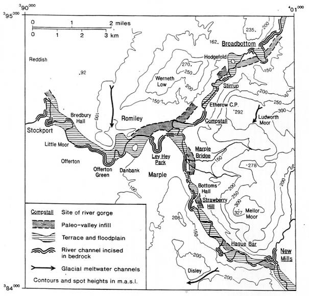
Figure 5.
|
Glacial gorges in the Goyt and Etherow valleys. |
At first, it was assumed that the gorges had been eroded in the post-glacial Holocene Period when the rivers began to remove the glacial deposits from their valleys. Where they became diverted to the side of the former valley they became incised into older Carboniferous strata and thus confined into a narrow rock defile. However, more recently, Johnson (1991) suggested that the gorges were glacial in origin and eroded by meltwater streams diverted by the last vestiges of ice in the valley. Such meltwaters could have incised their channels into the rocks at times when they flowed in courses marginal to the ice or when under hydrostatic pressure they flowed parallel to and under the stagnating ice margin.
At some time during the Last Glacial Maximum Stadial the valley floor in the Goyt and Etherow valleys was at a level only a few metres above present river level but by circa 18k.a. when the ice in the valley had begun to stagnate, glacial sediments varying in thickness had been deposited on the valley floor. These sediments (preserved in the Goyt buried valley and in the smaller tributary gullies) are up to twenty-five metres thick in places. It is therefore probable that by circa 16 k a. the valley floor was some 10 - 20 metres higher than the present river level. As the ice down-wasted large volumes of water from both the melted ice and the catchment’s snow fields fed the meltstreams and allowed them to transport considerable quantities of glacial and other sediments from the hill slopes. These streams became integrated into a single river system and (together with other erosional processes) began the work of removing the deposits left by the ice.
For the period from circa 16 k a. (when the remaining ice of the Last Glacial Maximum ice had disappeared from the British Isles) to the end of the Pleistocene Epoch at circa 11.6 k a. the climates were characterised both by extreme fluctuations of temperature and precipitation and the high frequency with which these fluctuations took place (Burroughs, 2005). At circa 14.6 k a. (during the Windermere Inter-Stadial) average temperatures were warmer than those experienced today and although down-cutting and erosion continued, the rates varied considerably. Initially, the Goyt River flowed in a valley of very restricted width throughout its length, but as down-cutting continued, irregularities in the channel caused the stream to meander. By shifting the position of the river channel laterally, undercutting the banks at each meander bend and depositing sediment as point bars wherever the current flow decreased, the river was able to both widen the valley floor and erode its channel to lower levels. In the gorges, where the more resistant sandstones were exposed, the river channels were restricted in any such lateral movement, but in other parts of the valley where glacial sediments or clayrocks formed the valley walls the river channels were able to develop meanders, although these were unable to move downstream through the gorges. This inability to migrate downstream caused the meanders to become increasingly modified in form but as they were confined within the valley the river channel gradient varied along its length. Where meandering took place the gradient was very low with frequent flooding causing silts and clays to be deposited over wide flood plains upstream of each gorge. In the gorges, where the stream gradient was steeper, down cutting continued but was restricted by the hardness of the rocks (Johnson, 1989).
However, a major climatic change took place when extreme cold conditions returned circa 12.9 k a., and lasted for over a thousand years (Burroughs 2005). During this time (known as the Loch Lomond Stadial), small glaciers were once again formed in the higher valleys of Snowdonia, the Brecon Beacons, the Lake District and the Scottish Southern Uplands and a small ice cap covered most of the Scottish mountain areas north of Loch Lomond. Elsewhere in England frost and other periglacial processes were extremely active in weathering the rocks and moving the debris down slope. In Mellor, the local relief was too low for the frost processes to modify the slopes to the extent that they did for example on Kinder Scout (Stevenson and Gaunt 1971) and the Mellor slopes remained covered with a glacial till veneer even on the local hill summit areas. On the steeper slopes some rock surfaces were exposed and the intense frosts would help to break up the more flaggy sandstones. Where the clayrocks were exposed to repetitive freeze-thaw changes, mass movements caused rock and soil materials to move down slope en-masse and even where the slopes were stable there was intensive soil creep on the slopes. Debris flows or minor mudflows known as solifluctional lobes are uncommon, but one is located north of Mellor Hall, and there have been other comparable mass movements elsewhere on the lower slopes of the Mill and Mellor Brook valleys. In the valleys not all the debris could be transported, and braided streams deposited an aggradation of coarser gravels creating a valley sandur or gravel 'train' spread along the Goyt valley floor. Now largely destroyed, the gravels of these sandurs were at least three metres thick in places, and those parts remaining now underlie the alluvial sediments found on the valley floor. At the close of this cold Stadial period the river channel was only a few metres above the present river level.
A return to warmer climatic conditions in the last ten thousand years has witnessed many changes in the landscape. On the hill slopes of Mellor and elsewhere in the South Pennines weathering and erosion continued with landslide movements taking place on the South Pennine hill slopes in the period from 9,000 to 6,500 years ago (Johnson 1985). The Landslides located on the slopes in Etherow Wood and on the slopes near Woodheys (Stevenson and Gaunt 1971) probably date from this period. Gradually, the local slopes became more stable and their soils developed to maturity with an extensive vegetation cover of deciduous woodland (dating from circa 8 k a. onwards) developed upon them. However, the most marked changes in the topography during this post-glacial (Holocene) period have taken place on the valley floors.
At the end of the glacial period in Europe there was a change from high melt stream discharges and a decrease in sediments loads to be transported in braided river systems to ones, where in the major valleys, a single river channel acted as the conduit in each drainage area. In pre-Roman times (i.e. before 2,000 k a) these rivers, flowing through forested basins, had discharges which were controlled by a series of climatic changes or cycles of some 2,000 years duration, during which the climate varied from cold-and-dry periods to ones where warm-and-wet conditions prevailed. Although flooding would take place at any time in the identified cyclic fluvial regimes, there were short periods of high flood frequency alternating with much longer more stable flows. In most rivers over-bank flooding resulted in the braiding of the stream course and scouring of the flood plain by the flood waters. Such conditions were then replaced by a second phase when the flood waters peaked and began to ebb resulting in renewed aggradation of sediment on the flood plain and a return to a single meandering river course. This in turn led to a third final and much longer phase where, with high stream discharges still prevailing, incision of the stream channel in its meandering course was renewed (Petts & Foster 1985).
In the Goyt and Etherow valleys however, the down cutting of the river channel throughout the valleys was also determined by the erosion of the river bed in each gorge. Because the meanders could not migrate downstream, their shape became increasingly distorted upstream of each gorge and this caused increased undercutting of the outer bank with concurrent construction of point bars and new flood plain levels at the edge of the channel inner margin. In each cycle, as a consequence of the renewed down-cutting taking place, new flood plain levels were formed, and sequence of abandoned flood plain remnants (terraces) at varying heights above the river in the Goyt and Etherow valleys were left to record the past morphological changes. These terraces have been mapped in both the Goyt and Etherow valleys upstream from Stockport being present in both the gorges and in the more open valley locations (Rice 1957, Simpson 1959, Stephenson et al 1971, Johnson 1989). In Brabyns Park terrace levels occur at 90m; 81m; 77 - 75m (the most extensive terrace) and 74-72m with the river channel level at 70m asl.
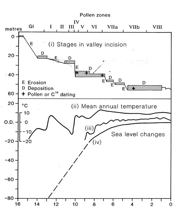
Figure 6
|
Schematic Diagram showing the correlation of past fluvial erosion and deposition events with former mean annual temperature fluctuations in Britain and changes of sea-level in the Irish Sea. The vertical axis scales indicate: (a) stages of valley incision measured downwards to present river level; (b) changes in sea-level; (c) mean annual temperature variation. The horizontal axis scales show Pollen Zone changes and a time scale ranging from 16k a B.P. onwards. It is worth noting that Pollen and Carbon 14 dates have shown that the 74 - 70m terrace levels in Brabyns Park date from between 10k a and 7k a B. P. |
The times at which the terraces were formed is uncertain but there is evidence to show that the highest valley-floor terrace was in existence before the end of the glacial period (Figure 6) and the largest terrace remnant was part of the floodplain some 8,000 years ago (Johnson 1989) and when sea levels in the Irish Sea were increasing in height to levels above present sea level (Tooley 1978). At this time the meanders increased in size and with the lateral shifts of the river through time an extensive flood plain was formed. Down-cutting of the river channel to a level below the lowest terrace in Brabyn’s Park must have taken place some time before 4,000 k a. (Johnson 1989), but the lower stream discharges then prevailing resulted in a smaller floodplain being formed.
In some of the higher terrace levels, lenticular beds of gravel are often present in the flood plain sediments, but with deforestation occurring from Pre-Historic to Medieval times, and with subsequent changes in land-use, increased amounts of silt and clay were transported by the rivers. Frequent flooding allowed the build up of an alluvial cover which on the lower terrace levels is often over a metre thick. In more recent times, changes in land drainage and agricultural practice have occurred leading to renewed incision of the main river channels.
In the Mellor Parish, there is a broad terrace now some 3-4 metres above river level, upstream of Strawberry Hill. This same terrace is present downstream of the gorge, but was modified and the river channel diverted when the Roman Lakes were constructed. Further downstream in Marple Bridge more terraces are found in Lower Fold west of Ludworth Primary School, and in the Etherow valley downstream of Compstall (Plate 6). These terraces can be matched in their altitudinal heights above sea level with the terraces in Brabyns Park.
The Mellor landscape today, although still containing a record of its past geological history, is now a product of Man's work as a geological agent. Woodland clearances, continuing and ever changing agricultural and industrial practices, field enclosures and the growth and spread of settlement have fashioned the modern landscape through periods of changing climate. These do not compare in magnitude with those experienced in the Pleistocene or early Holocene Periods but are still significant. Finally in more recent times the channels of the Goyt and Etherow rivers and some of their tributary streams have been diverted or straightened when various eighteenth century textile mill sites were selected. These sites were often at locations where a good head of water for generating a steady supply of power at the mill site was available. Such locations occur where there is an increase in the stream velocity through a Goyt or Etherow river gorge or where streams flow over a resistant rock outcrop.
Plate 6
|
Viewed from the south this Google Earth image shows the confluence area of the rivers Goyt and Etherow. Between the river gorges upsteam at Marple Bridge and Compstall and the gorge downstream of the Marple Aqueduct, the rivers have developed a wide valley tract in which a number of terraces were formed by the meandering river channels. The river meanders unable to migrate down-valley have become distorted in shape and are confined by the width of the valley segment in which they are located. |
Frequent flooding and the lateral extension of the
floodplains have been a feature of the historic period, but the construction of
reservoirs and better river channel management have greatly reduced the flood
hazard, although changes to the river channel course continue to take place.
Recent changes in the river Goyt channel include:
a) the growth over the past fifty years of the small ait (island) immediately
upstream of the Iron Bridge in Brabyns Park;
b) the rapid silting up of the Forge Mill millpond in Marple Bridge after the
reconstruction of the mill wheel;
c) the local flood in 1972;
d) the collapse of the Town Street river wall in 1991.
1. The deposition of the Carboniferous strata was followed by the Variscan Orogeny, during which tectonic forces created a series of fold structures that have a north-south alignment in the Mellor district and have been much affected by faults. During the whole of the Mesozoic and into the Cenozoic Periods these strata were buried by younger sedimentary rocks and the exhumation of the Carboniferous rocks from beneath this cover only started in late Tertiary times.
2. In the early Tertiary Period the British Isles were affected by tectonics associated with the opening of the Atlantic Ocean. The major uplands of Britain including the Pennines were formed and by the start of the Pliocene, (circa 5 M a) the ancestors of the present day rivers were probably enlarging their catchments by exploiting any weaknesses such as fault lines or clayrock formations exposed in the Carboniferous fold structures.
3. The rates of erosion were increased during the Pleistocene Period when ice and meltwater streams were present in the Mellor area. However, as each glacial transgression destroyed the evidence of previous glacial periods, only the residual deposits and landforms created during the Last Glacial Maximum (23 - 16 k a) are in evidence at the present time.
4. During the Last Glacial Maximum ice covered the South Pennine hills to the west of Kinder Scout. During the down-wasting and stagnation of ice at the ice sheet margin, a mantle of tills, sands and gravels were deposited which when traced down slope and towards the valley floor increases in thickness. At the time when the col channels were eroded the ice was largely impermeable and too thick to allow meltwaters to penetrate very far into the glacier, but increasingly meltwaters became the dominant erosive process as the ice sheet melted. With prolonged down wasting the ice became heavily crevassed and ultimately the meltwaters could penetrate to its base. At such times the streams began to modify existing valleys, initiating the erosion of gorges in the Goyt and Etherow valleys and sorting or redistributing the glacial sediments.
5. Very variable climatic conditions characterised the end of the Pleistocene Period (16 - 10 k a). Within the present catchment the meltwaters that had flowed in a series of braided channels became increasingly integrated into a single river system. As a consequence the river Goyt developed a course linking the gorges and where the valley sides were formed of less resistant clayrocks or glacial sediments began to increase the width of the valley by under cutting the slopes. Meanders were developed and although still confined by the width of the former valley trench, these helped to form the local flood plain areas.
6. For a period of over a thousand years during the Loch Lomond Stadial (12.9 - 11.6 k a) there was a return to much colder but not glacial conditions. Frost processes would have been very intensive at this time and where the ground remained permanently frozen seasonal surface stream discharges were increased as were the sediment loads transported. This led to aggradation within the stream channels and the formation of sandur gravel flood plains.
7. At the end of the Pleistocene Epoch the rivers began to erode the gravels but widespread flooding regularly occurred and a silty clay alluvium was deposited to form flood plains over much of the valley floor. As down cutting continued a number of terraces at various height levels above the present river channel were left and these indicate not only how the river meanders have shifted in position through time but also how down cutting by the river has been both variable and episodic.
Acknowledgement is gratefully given to Dr Fred Broadhurst for his advice and help when undertaking this study, and to Dr Phillip Day, Steve Johnson and Helen Pakpahan for their help in preparing this paper for presentation on the Web. Figures 5 & 6 have been previously published in The Manchester Geographer 1989 Vol.10.
References.
BENN, D.J. and EVANS, D.J.A. (1998) Erosional Forms and Landscapes IN Glaciers and Glaciation Arnold pp328-332
BENNETT, M.R. and GLASSER, N.F. (1997) Box 8.5. The Interpretation of Multiple Till sequences. IN Glacial Geology Ice Sheets and Landforms Wiley p201
BURROUGHS, W. (2005) Climate Change in Prehistory Cambridge: Cambridge University Press pp42-47
CHADWICK, R.A. (2002) Chapter 9, Structure, IN British Regional Geology, The Pennines and adjacent areas British Geological Survey p131-3.
CROFTS, R. G. (2005) The Quaternary of the Rossendale Forest and the Greater Manchester area and its regional setting within North-West England. IN Quaternary of the Rossendale Forest and Greater Manchester. R.G. Crofts (Ed.) Quaternary Research Guide 2005 pp1-10
GLASSER, N.F. and SAMBROOK SMITH, G.H. (1999) Glacial meltwater erosion of the Mid-Cheshire Ridge: implications for ice dynamics during the Late Devensian glaciation of northwest England J. Quaternary Science 14(7) pp703-710
HOLDSWORTH, R.E., WOODCOCK, N.H. and STRACHAN ,R.A. (2002) Geological framework of Britain and Ireland IN Geological History of Britain and Ireland N.H. WOODCOCK & R. A. STRACHAN (Eds) London: Blackwell pp19-40.
HULL, E. (1864) Geology of the country around Oldham, including Manchester and its suburbs Memoir Geol. Survey Great Britain.
JOHNSON, R.H. (1969) The Glacial Geomorphology of the area around Hyde, Cheshire Proc.Yorks. Geol.Soc. 37 pp188-230
JOHNSON, R.H. (1985) The imprint of glaciation on the west Pennine uplands IN The Geomorphology of north-west England R. H. JOHNSON (Ed) Manchester: Manchester University Press pp237-262
JOHNSON, R.H. (1987) Some Evidence for a Glacial Corrie at Seal Edge, Kinder Scout, North Derbyshire The Manchester Geographer, 8 pp37-48.
JOHNSON, R.H. (1989) The Late Glacial and Post Glacial History of the River Goyt: Some Further Evidence The Manchester Geographer (volume no missing) p26-41
JOHNSON, R.H., TALLIS, J.H. and WILSON, P. (1990) The Seal Edge Combs, North Derbyshire J. Quaternary Science, 5(1), pp83-94
JOHNSON, R.H. (1991) Goyt Valley between Marple and Stockport Itinerary XII. IN Geology of the Manchester Area R. M. C. EAGAR and F. M. Broadhurst (Eds.) Geologists Association Guide no 7. pp82-85
PETTS, G and FOSTER, I. (1985) Rivers and Landscape Edward Arnold pp210-212.
RICE, R.J. (1957) Some Aspects of the Glacial and Post-Glacial History of the Lower Goyt Valley, Cheshire Proc. Geol. Assoc. 68(3), pp217-22
SIMPSON, I.M. (1959) The Pleistocene Succession in the Stockport and South Manchester area J. Geol. Soc. London, 115, pp107-119
STEVENSON, I.P. and GAUNT, G.D. (Eds.) (1971a) Chapter VIII Structure, IN The Geology of the country around Chapel-en-le-Frith. Mem. Geol. Surv. Gt. Br. pp321-326.
STEVENSON, I.P. and GAUNT, G.D. (Eds.) (1971b) Chapter IX Pleistocene and Recent, IN IN The Geology of the country around Chapel-en-le-Frith. Mem. Geol. Surv. Gt. Br. pp329-356.
TOOLEY M.J. (1978) Sea-level changes in North-West England during the Flandrian Stage, Oxford: Clarendon
WORSLEY, P. (2005) The Cheshire Shropshire Plain IN The glaciations of Wales and adjacent areas C. A. LEWIS and A. E. RICHARDS (Eds) Logaston Press pp59-72.